|
Total Metals Corp.
July 13, 2026, Toronto, ON - Total Metals Corp. (“Total Metals” or the “Company”) (TSX-V: TT) (OTCQB: TTTMF) (FSE: O4N) is pleased to announce the results from the fifteen remaining unreleased drill-holes in its 8,408 metre, 25 hole winter drilling program at the Electrolode critical metals property, located in northwestern Ontario (the “Project”) completed in early 2026. Detailed results for the first ten holes were previously released on June 22, 2026.
The 3,300 hectare Electrolode property, located 69 km from Ear Falls, Ontario hosts the Arrow Zone with a NI 43-101 compliant current Inferred Mineral Resource1, with an effective date of June 1, 2025, containing 2.11 million tonnes averaging 0.66% Cu, 4.74% Zn, 17.92 g/t Ag and 0.66 g/t Au.
Ten other mineralized zones have been identified and explored on the property by previous operators including those in the Copperlode area 4.5 km southwest of Arrow. These were all systematically reviewed by Total Metals along with newly identified targets that together were ranked and selected for follow-up drill testing. The 2026 program has demonstrated that the Project has considerable potential remaining for increasing metal resources at the Arrow Zone as well as the Hornet Zone. Also, the area under Garnet Lake has significant exploration potential and is considered a priority area for future programs.
HIGHLIGHTS
Copperlode Area
High Grade copper intercept received at Copperlode.
Hole EL-26-013 returned 2.90% Zn, 1.15% Cu, 0.06 g/t Au, 13.30 g/t Ag over 7.67 m core length for the Hornet Zone
Includes 3.62% Zn, 3.19% Cu, 0.23 g/t Au, 37.29 g/t Ag over 1.74 m
Anomalous zinc and copper results from other targets together with revised geologic models support a strong target base for future critical metals exploration that could potentially increase metal resources at the Arrow Zone as well as the Hornet Zone.
The program 2026 winter drill program at Electrolode was an overall success taking into account for significant results from the Arrow Zone previously released2 on June 22, 2026:
Hole EL-26-006 returned 8.40% Zn, 0.40% Cu, 0.35 g/t Au, 21.88 g/t Ag over 4.00 m core length for the Arrow Zone
Includes 20.05% Zn, 0.23% Cu, 0.33 g/t Au, 27.54 g/t Ag over 1.54 m containing an interval of 37.38% Zn over 0.73 m
Hole EL-26-006 also returned 7.81% Zn, 1.90% Cu, 0.72 g/t Au, 56.51 g/t Ag over 4.30 m core length for a zone in the hanging wall of the Arrow Zone
Includes 16.91% Zn, 3.59% Cu, 1.33 g/t Au, 116.77 g/t Ag over 1.91 m containing an interval of 38.20% Zn over 0.42 m
Hole EL-26-003A returned 7.00% Zn, 0.47% Cu, 0.25 g/t Au, 32.73 g/t Ag over 7.18 m core length for the Arrow Zone
Includes 20.14% Zn, 0.89% Cu, 0.37 g/t Au, 112.29 g/t Ag over 1.70 m
Hole EL-26-004 returned 3.85% Zn, 0.50% Cu, 0.19 g/t Au, 18.59 g/t Ag over 9.75 m core length for the Arrow Zone
Includes 20.44% Zn, 0.98% Cu, 0.21 g/t Au, 39.07 g/t Ag over 1.45 m
Hole EL-26-002 returned 5.10% Zn, 0.50% Cu, 0.41 g/t Au, 18.21 g/t Ag over 4.55 m core length for the Arrow Zone
“The first-pass regional drilling completed in early 2026 was a resounding success, fundamentally upgrading our geological model and confirming that both the Arrow and Hornet Zones remain wide open for expansion.” commented Tyler Thorburn, President & CEO. “We are now advancing a systematic, data-driven strategy to unlock Electrolode’s ultimate value. By leveraging modern, deep-penetrating geophysics and fully integrating a wealth of historical data, we are sharpening our drill targets with precision. We have a clear line of sight to significant resource growth.”
Technical Details
The 2026 winter drill campaign, initially planned for 5,500 metres with one rig, was activated in late January, and was subsequently ramped up to an 8,000 metre program with the addition of a second rig. Drilling ended in mid-April with 25 holes completed totalling 8,408 metres. The distribution of drill-holes, shown in Figure 1, targeted two main sectors: the Arrow / Garnet area and the Copperlode area, as well as a variety of other targets planned on the basis of compiled geology combined with recent 3D geophysical modeling by external consultants. A 3D magnetic inversion model was created from an October 2024 high resolution UAV-borne survey completed by EarthEx Geophysical Solutions Inc. over the Copperlode area using their eMAG system. Maxwell plate models were also created, derived from data for selected electromagnetic conductors identified in a May 2017 VTEMTM plus survey by Geotech Ltd. for Pistol Bay Mining Inc. over a large area that covers the Electrolode property.
The main targets on the property are volcanogenic massive sulphide (VMS) deposits, though being cognizant of location in the Red Lake district, prospective structures for gold are also evaluated.
The focus of the information disclosed in this release are the results of drilling completed in the Copperlode area as well as from geophysical targets within a 2 km corridor southwest of Arrow / Garnet.
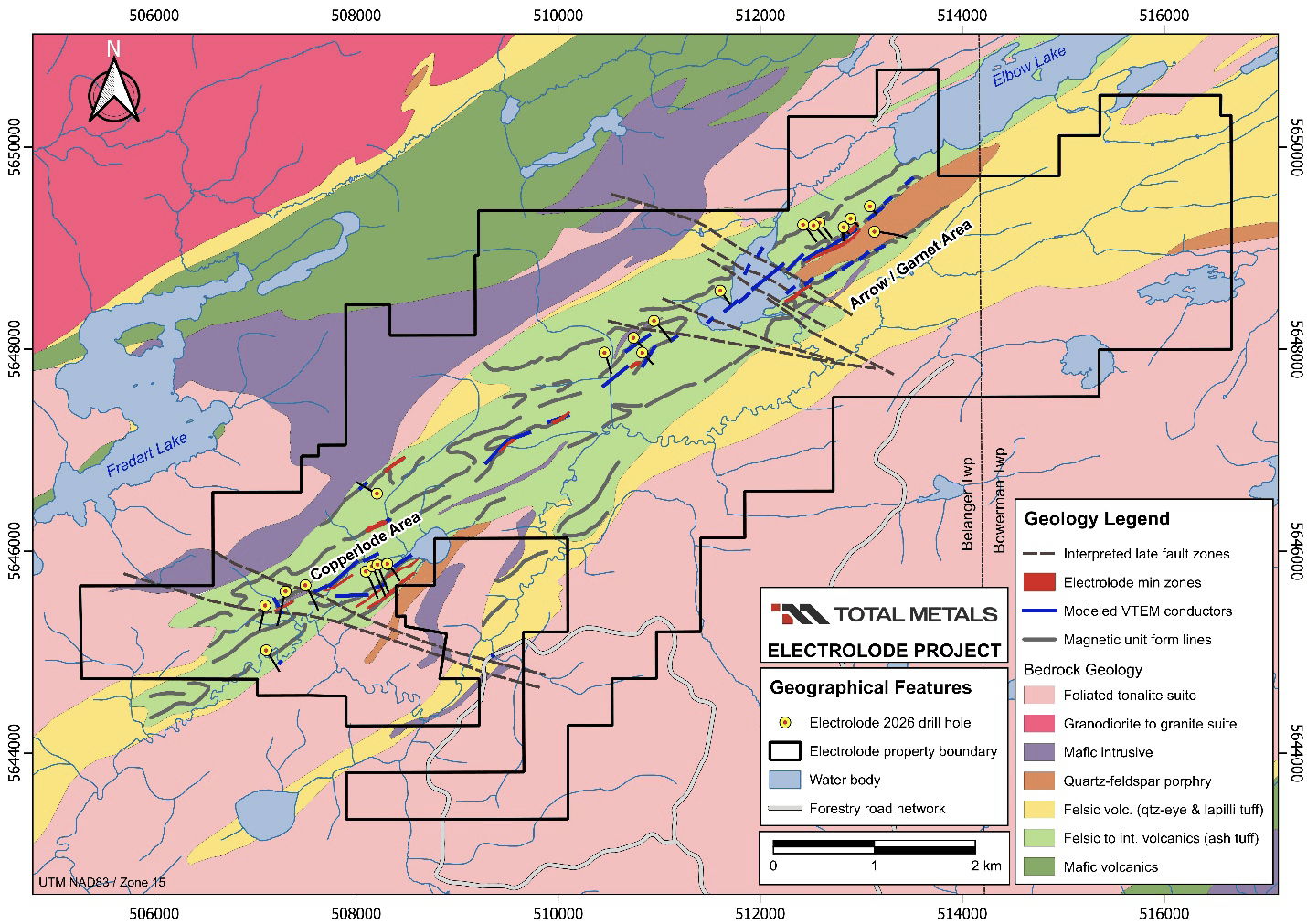
Figure 1. Surface geology of the Electrolode property showing distribution of drill-holes completed in 2026 winter program. Results from the Arrow / Garnet area were previously released on June 22, 2026.
Within the Copperlode area, a total of 7 holes were drilled on the Copperlode zones themselves, and 3 holes were drilled on peripheral target areas. In the 2km corridor southwest of Arrow Zone, a total of 5 holes were drilled. Table1 summarizes drill-hole coordinates, hole orientation as well as target information for the fifteen holes.
Table 1. List of remaining unreleased drill-holes completed during the 2026 winter drill program outside of the Arrow / Garnet area.
Hole Number | UTM ^Easting | UTM ^Northing | Elevation (m asl) | Final Depth (m) | Azimuth (degrees) | Dip (degrees) | Target Area |
|---|---|---|---|---|---|---|---|
EL-26-011 | 507499 | 5645662 | 390.2 | 345.00 | 149.00 | -45 | Copperlode |
EL-26-012 | 507100 | 5645462 | 391.5 | 345.00 | 153.00 | -45 | S-CL Fault |
EL-26-013 | 508096 | 5645799 | 390.9 | 516.00 | 154.00 | -62 | Copperlode |
EL-26-014 | 507302 | 5645601 | 387.8 | 450.00 | 195.00 | -45 | Copperlode |
EL-26-015 | 507109 | 5645018 | 383.7 | 336.00 | 145.00 | -45 | L13 Target |
EL-26-016 | 508157 | 5645850 | 392.5 | 513.44 | 152.00 | -59 | Copperlode |
EL-26-017 | 508207 | 5646570 | 403.2 | 303.00 | 295.00 | -45 | L5 Target |
EL-26-018 | 510459 | 5647966 | 402.1 | 390.00 | 155.00 | -63 | Far East |
EL-26-019 | 508212 | 5645866 | 390.3 | 528.00 | 158.00 | -65 | Copperlode |
EL-26-020 | 510747 | 5648113 | 400.3 | 318.00 | 135.00 | -45 | Far East |
EL-26-021 | 510834 | 5647965 | 396.4 | 201.00 | 135.00 | -45 | Far East |
EL-26-022 | 510949 | 5648280 | 404.3 | 354.00 | 131.00 | -45 | Far East |
EL-26-023* | 508308 | 5645873 | 390.3 | 129.00 | 153.00 | -67 | Copperlode |
EL-26-024 | 508309 | 5645874 | 390.6 | 458.00 | 139.00 | -66 | Copperlode |
EL-26-025 | 511606 | 5648579 | 401.2 | 240.00 | 142.00 | -50 | Garnet Lake |
^Collar coordinate datum NAD83 / Zone 15
*Hole stopped due to excessive deviation, recollared as EL-26-024
The Copperlode Zone is comprised of five separate bodies of VMS mineralization that have potential for developing coherent mineral resources similar to the Arrow Zone deposit. The Hornet and E zones have reported historic copper and zinc resources that have not been updated to 43-101 compliant standards. Drill-holes completed in the Copperlode area during the 2026 program (Figure 2) includes holes testing some of these zones as well as holes targeting other targets defined by structural breaks, geophysics or areas of intense rock alteration.
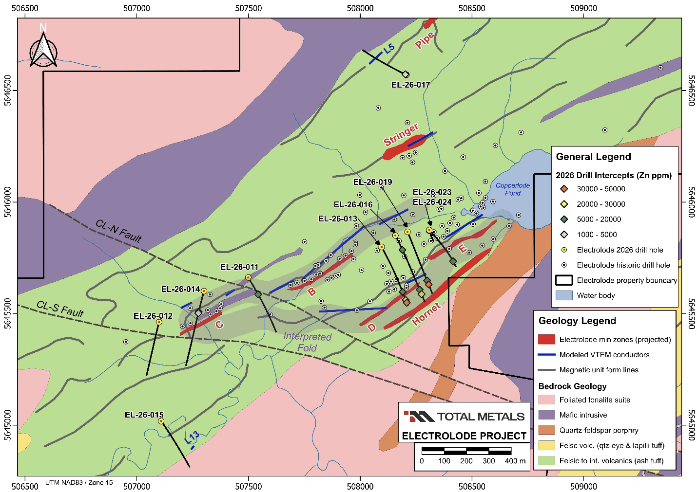
Figure 2. Surface geology of the Copperlode area showing the location of holes completed in the sector during the 2026 winter drilling program. Results from 7 holes targeting the Copperlode zones (Hornet, B, C, D and E zones) are presented in Table 2. Results for other 3 holes drilled on peripheral targets are listed in Table 3.
Drill-holes targeting the Copperlode zones (EL-26-011, EL-26-013, EL-26-014, EL-26-016, EL-26-019, EL-26-023 and EL-26-024) were designed to test a geological concept that emerged from compiled historic geological mapping together with recently modeled property geophysics. This concept indicates that the Copperlode zones are contained within an envelope of folded volcanic stratigraphy that are cross-cut by a pair of faults (CL-N and CL-S). Hole EL-26-012 was drilled to test the CL-S fault as well as an area intense VMS-style footwall wall-rock alteration. Similarly, hole EL-26-015 tested an area of documented intense VMS-style footwall alteration adjacent to an intrusive contact. In the northern part of this sector, hole EL-26-017 was drilled to test a conductor along strike of the historic Pipe Zone. Results for holes drilled in the Copperlode area are summarized in Table 2 (Copperlode zones) and Table 3 (other peripheral targets).
Table 2. Significant assay results from the Electrolode winter 2026 drilling targeting the historic Copperlode zones.
Hole Number | From (m) | To (m) | Length * (m) | Zone | Zn % | Cu % | Au (ppm) | Ag (ppm) |
|---|---|---|---|---|---|---|---|---|
EL-26-011 | 119.05 | 122.00 | 2.95 | C Zone / CL-N | 0.78 | 0.05 | 0.00 | 2.72 |
EL-26-013 | 410.60 | 411.17 | 1.01 | D Zone | 1.24 | 0.06 | 0.01 | 10.35 |
EL-26-013 | 470.72 | 478.39 | 7.67 | Hornet | 2.90 | 1.15 | 0.06 | 13.30 |
Includes | 475.03 | 478.39 | 3.36 | Hornet | 4.02 | 1.25 | 0.11 | 15.38 |
Also Incl. | 474.58 | 476.32 | 1.74 | Hornet | 3.62 | 3.19 | 0.23 | 37.29 |
EL-26-013 | 495.20 | 495.94 | 0.74 | FW to Hornet | 4.29 | 0.07 | 0.01 | 4.82 |
EL-26-014 | 131.30 | 135.00 | 3.70 | C Zone / CL-S | 1.02 | 0.06 | 0.00 | 3.06 |
EL-26-014 | 140.40 | 143.10 | 2.70 | FW to C Zone | 0.38 | 0.10 | 0.00 | 5.79 |
EL-26-016 | 130.48 | 132.50 | 2.02 | E Zone | 0.85 | 0.16 | 0.04 | 6.85 |
EL-26-016 | 435.44 | 438.00 | 2.56 | D Zone | 1.89 | 0.04 | 0.01 | 9.17 |
EL-26-016 | 466.26 | 468.21 | 1.95 | Hornet | 2.19 | 0.12 | 0.01 | 22.98 |
EL-26-019 | 433.35 | 437.90 | 4.55 | D Zone | 0.91 | 0.18 | 0.01 | 22.4 |
EL-26-019 | 464.35 | 465.50 | 1.15 | Hornet | 3.19 | 0.10 | 0.01 | 12.41 |
EL-26-023 | NSV (Hole Abandoned – Did Not Reach Target) | |||||||
EL-26-024 | 404.45 | 405.50 | 1.05 | Hornet | 1.69 | 0.01 | 0.01 | 5.18 |
*Reported as core length. True thickness estimates not available.
NSV = No significant assay results
Drill-holes targeting the D, E and Hornet zones were drilled well below the Maxwell plates models to test confirmation of fold geometry and depth continuity. The best result received for Copperlode is from hole EL-26-013 where an interval of 2.90% Zn, 1.15% Cu, 0.06 g/t Au and 13.30 g/t Ag over 7.67 metres core length was intersected 395 metres below surface in the Hornet Zone. This interval also contained elevated gallium (23.93 ppm Ga) and indium (26.77 ppm In). The other holes targeting this area intersected narrower intervals of lower-grade zinc (<3% Zn) and copper mineralization (<0.20% Cu) confirming mineralization continues within the interpreted geometry.
Figure 3 illustrates the 3D geophysical concept of targets, showing the drill-hole trajectories relative to Copperlode Maxwell plates as well as other structural features tested. Holes EL-26-011, EL-26-012 and EL-26-014 intersected either the CL-N or CL-S fault. No anomalous Zn, Cu, Au or Ag values from the drill program were associated with these structures. Geological observations from core logging noted these structures as moderate to intense silicification features later brecciated with clay-filled gouge suggesting either a protracted history for these structures in this area, or the faults are cutting an area of pre-existing syn-volcanic VMS alteration. Hole EL-26-011 noted an increase of aluminosilicates (staurolite and garnet) as well as the absence of magnetite towards the end of the hole which is spatially coincident with the edge of a prominent low magnetic feature between the two faults.
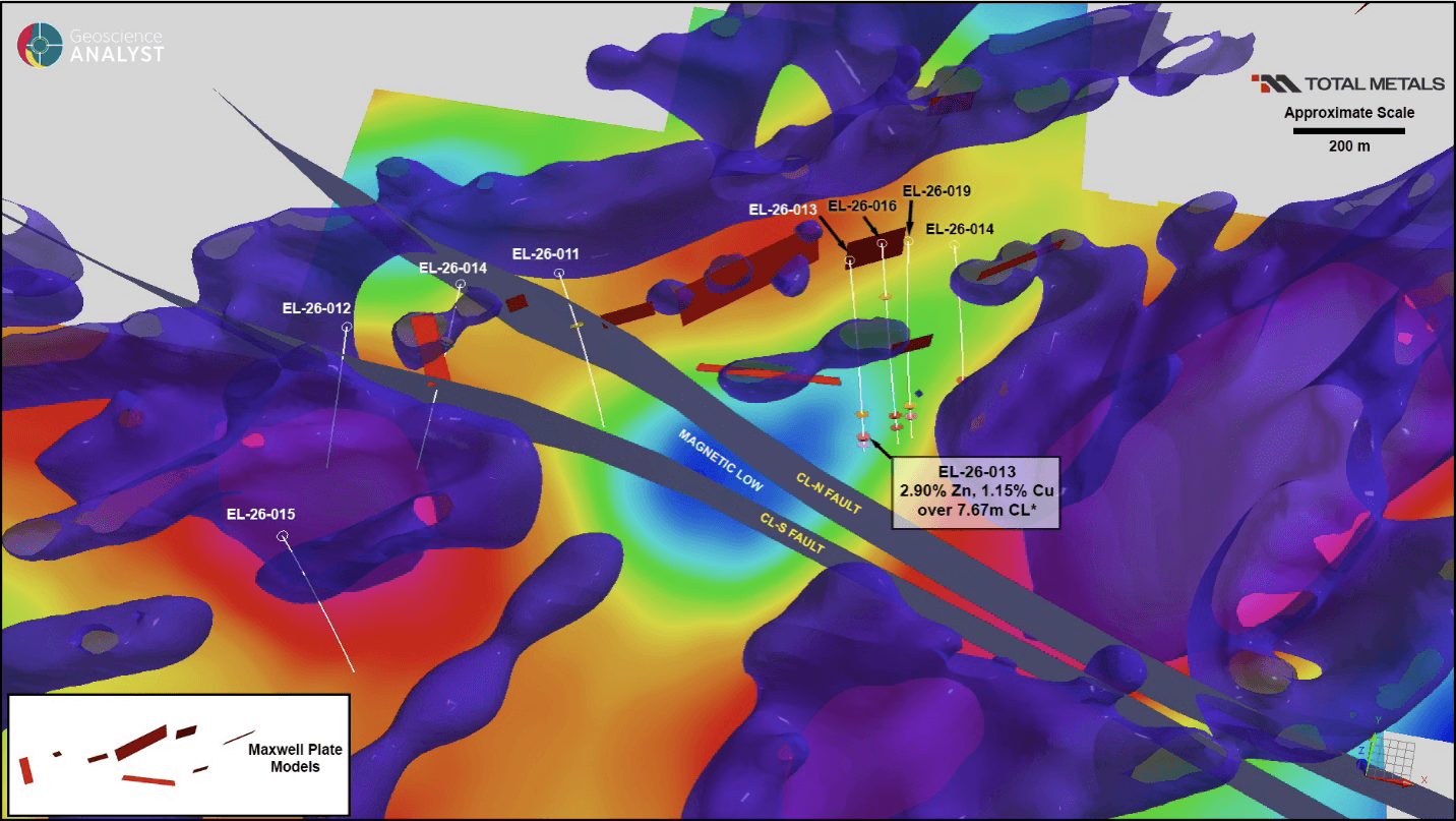
Figure 3. Geophysical and structural features targeted in the Copperlode area shown in 3D tilted plan view looking north. 3D magnetic inversion represented by semi-transparent purple isoshells outlining elevated magnetic units (magnetic susceptibility >0.00274 SI). Full colour horizontal section represents magnetic susceptibility at -300 m below surface. Nested within the inversion model are Maxwell plate models derived from the 2017 VTEM survey over the Property. The interpreted planes of the north steeply dipping CL fault zones are also shown together with 2026 program holes which have tested some of the features shown.
Drill-hole EL-26-015 did not return any significant values for the same folded magnetic unit also tested by holes EL-26-012 and EL-26-014 south of the CL-S fault, although the strong VMS alteration noted from historic mapping is present throughout the hole. Hole EL-26-017 targeting a conductor on strike with the Pipe Zone intersected an anomalous copper-zinc interval at the top of the hole, but not at the targeted depth elevation corresponding to the Maxwell plate model.
In the trend between the Arrow / Garnet and Copperlode areas, numerous VTEM conductors were modelled as Maxwell plates, but within the limited drilling window only a select few were drilled during the program (Figure 4).
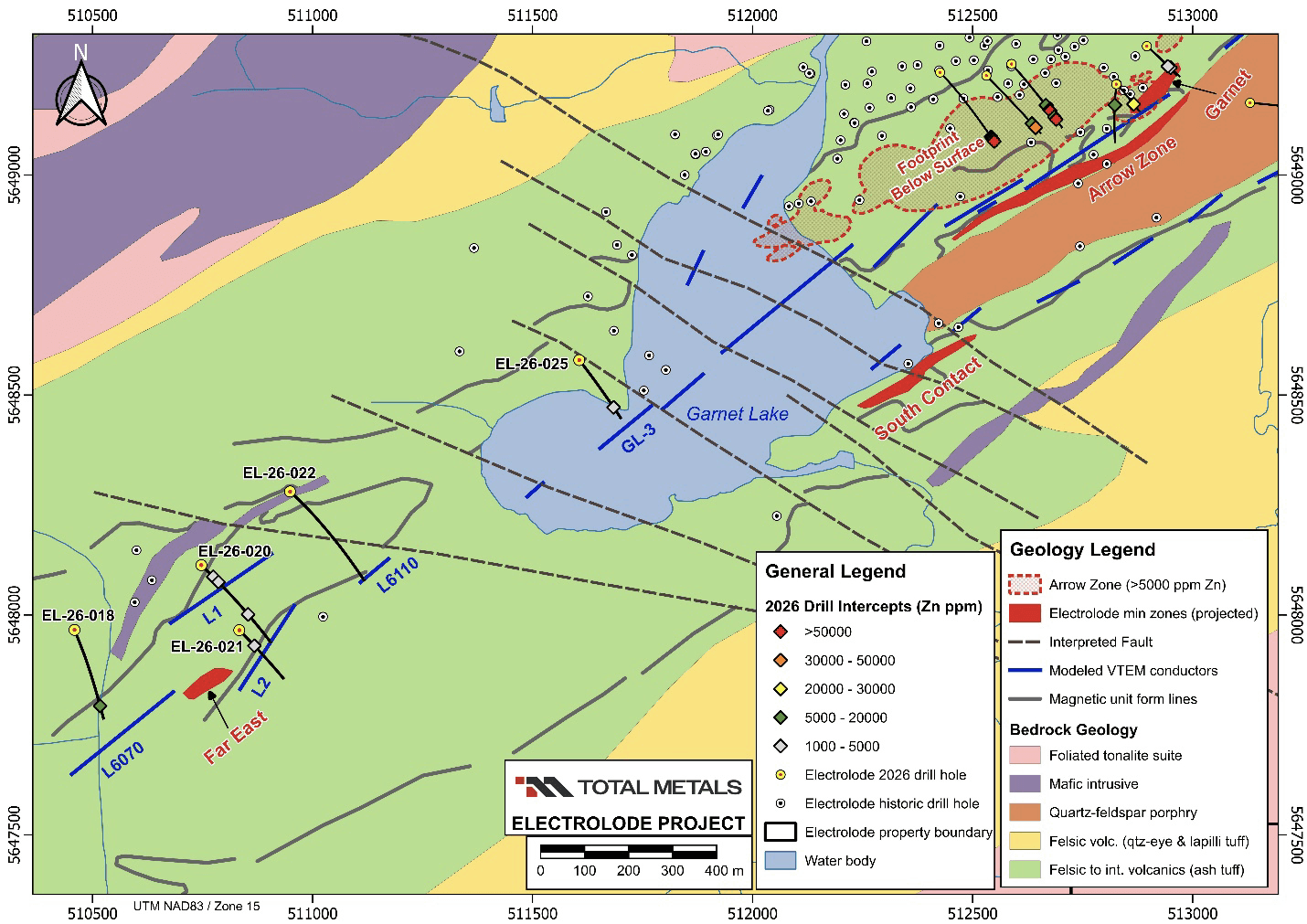
Figure 4. Surface geology of the Garnet Lake – Far East area showing the location of holes completed in the 2 km corridor southwest of the Arrow Zone. Collars for previously holes EL-26-001 to EL-26-010 drilled at Arrow are shown for reference but not labelled (please refer to the June 22, 2026 release for description and results).
Four drill-holes (EL-26-018, EL-26-020, EL-26-021 and EL-26-022) were drilled testing a group of conductors spatially associated with the northernmost lens of the Far East Zone. All holes drilled in this area intersected each targeted plate model which progressively step deeper below surface to the southwest from plate L6110 to L6070. With the exception of hole EL-26-022, all holes intersected anomalous zinc and copper values. The result from EL-26-018 (14,220 ppm Zn) is interesting in that the Maxwell plate modelling identified L6070 as a deep conductor that was not known previously.
Table 3. Significant assay results from the Electrolode winter 2026 drilling targeting other Property exploration targets.
Hole Number | From (m) | To (m) | Length * (m) | Target | Zn (ppm) | Cu (ppm) | Au (ppm) | Ag (ppm) |
|---|---|---|---|---|---|---|---|---|
EL-26-012 | - | - | - | CL-S | NSV | |||
EL-26-015 | - | - | - | L13 | NSV | |||
EL-26-017 | 7.00 | 8.00 | 1.00 | L5 | 1220 | 16000 | 0.12 | 19.50 |
EL-26-018 | 342.20 | 343.40 | 1.20 | Far East L6070 | 14220 | 732 | 0.03 | 8.85 |
EL-26-020 | 51.00 | 55.20 | 4.20 | Far East L1 | 2085 | 310 | 0.04 | 1.80 |
EL-26-020 | 75.20 | 77.00 | 1.80 | Far East L1 | 3298 | 763 | 0.13 | 4.70 |
EL-26-020 | 208.00 | 214.80 | 6.80 | Far East L2 | 1755 | 1167 | 0.05 | 3.61 |
EL-26-021 | 67.95 | 69.40 | 1.45 | Far East L1 | 4299 | 340 | 0.05 | 2.96 |
EL-26-022 | - | - | - | Far East L6110 | NSV | |||
EL-26-025 | 196.30 | 202.15 | 5.85 | GL-3 Plate | 1844 | 174 | 0.01 | 1.05 |
*Reported as core length. True thickness estimates not available.
NSV = No significant assay results
The results of geological compilation and modeling suggest the presence of northwest trending faults that disrupt the pattern of magnetic features within the volcanic stratigraphy southwest of the Arrow Zone. Late in the drill program, additional Maxwell plate models were created for VTEM conductors in the Arrow / Garnet area continuous to the conductors drilled in the Far East Zone area. As a result of the continuity of the conductor trend from Arrow to the southwest, the area under Garnet Lake was determined to be an area of high potential. However, because of limitations to access and drill set-ups late in the program only one conductor, GL-3, could be drilled. Hole EL-26-025 targeted the centre area of the Maxwell plate for GL-3 (Figure 5) returning anomalous zinc and copper values.
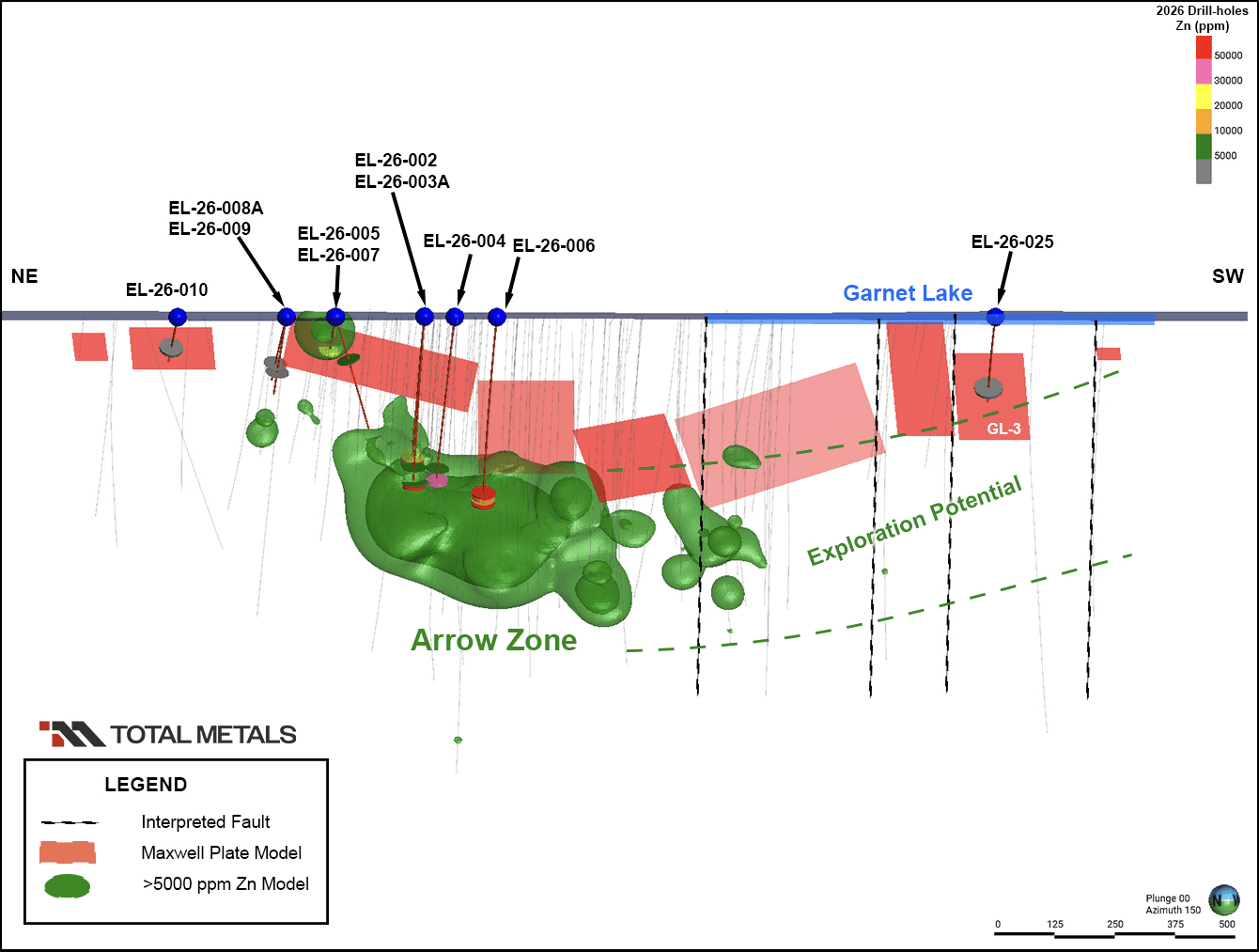
Figure 5. Vertical section looking southeast showing Arrow Zone >5000 ppm Zn numeric model together with modeled Maxwell plates and interpreted faults (note: fault dips not known but are assumed to be near-vertical). Area of exploration potential is highlighted under Garnet Lake.
Figure 5 is a vertical section showing the spatial location of Maxwell plate models relative to the Arrow Zone >5,000 ppm Zn footprint. From this view, it is apparent that Maxwell plates associated with the Arrow Zone do not extend at depth to the main body of mineralization due a possible depth limitation for the VTEM survey below 350 m in this area. This relationship supports a reasonable conclusion that exploration potential exists below Maxwell plates extending to depth (>300 m below surface). In this scenario, the area under Garnet Lake has significant exploration potential and is considered a priority area for future programs.
Next Steps
This regional evaluation of the Electrolode Property has demonstrated that the Project has considerable potential remaining for increasing metal resources at the Arrow Zone as well as the Hornet Zone. The 2026 program was designed as a first pass regional assessment of selected targets and has added considerable detail to the geologic model of the property. To further enhance understanding and continue testing critical metals potential on the property, the anticipated next steps for the project are:
Model and incorporate all remaining data including ground geophysical surveys, borehole geophysics, detailed drill logs and rock geochemistry previous operators.
Evaluate the application of various commercial deeper “seeing” geophysical methods suited for the mineralization styles at Electrolode.
Review and re-rank targets, and if warranted, prepare a new exploration permit to better position possible future drilling to test targets that were not accessible in the current permit, including those under Garnet Lake.
QA/QC Procedures
Protocols for core logging, sampling and QAQC were developed together with Bayside Geoscience Inc., who managed project site exploration activities on behalf of and under direction of the Company during the duration of the winter drilling program. Drilling was contracted to Platinum Diamond Drilling Inc. with NQ2 size core produced. Once the core was logged and marked for sampling, samples were sawn in half. Certified reference material standards and blanks were inserted into the sample sequence on a rotating basis and together combined with sealed samples in zip tie secured rice bags and securely delivered by Bayside personnel to AGAT Laboratories Ltd. All sample preparation and 30 g fire assay ICP-OES finish was completed in Thunder Bay and all 4-Acid digestion and 48 multi-element analysis (ICP-OES/ICP-MS finish) was done at AGAT’s Calgary location. Samples >1% Zn, >1% Cu and >100 g/t Ag were reanalyzed as over limit with AGAT’s 4-Acid Metals Package (ICP-OES and/or ICP-MS finish). Internal laboratory standards and blanks were also analyzed by AGAT and reported with the certified assay results. A selected subset of mineralized sample pulps and additional CRMs were shipped and analyzed by a third-party lab independent of AGAT for further verification.
Footnotes
1NI43-101 Technical Report on the Electrolode Property, Belanger and Bowerman Townships, Red Lake Mining Division, Ontario, Canada by Colin Bowdidge. Effective Date: June 1, 2025
2See Total Metals Press Release dated June 22, 2026, “Total Metals Reports Positive Results at its Electrolode Critical Metals Project – Including High-Grade intercepts up to 38.20% Zinc over 0.42m and 3.59% Copper over 1.91m” for complete details.
Qualified Person
Robert Penczak, M.Sc., P.Geo (Ontario), Vice President of Exploration for the Company and a Qualified Person as defined by National Instrument 43-101, has reviewed and approved the scientific and technical information used in this news release.
About Total Metals Corp.
Total Metals Corp. is focused on developing and advancing its high-grade gold and critical mineral assets located in Eastern Canada. The Electrolode Project is targeting high-potential critical mineral plus gold resources and targets in three favorable geologic trends, located near major mines in the Red Lake Gold camp and is strategically located between Kinross Gold’s Great Bear Project and First Mining Gold’s Springpole Project. The Electrolode Project is fully permitted for exploration drilling and hosts 10 historic mineralized zones with significant expansion potential plus new, untested targets ready for further exploration. Total Metals also owns 100% of the High Lake and West Hawk Lake Project covering 958 hectares in two gold properties located along the Trans-Canada Highway straddling the Manitoba / Ontario border. The Purdex Zone on the High Lake property has significant exploration potential and will be the primary target for initial exploration and potential future mining activities. The West Hawk Lake property is comprised of a single mineral lease, located within southeastern Manitoba. The Company has an option on the Menary gold property, strategically located in the Kenora Mining Division of Ontario, sharing a common southern boundary with the Rainy River claims being acquired by Coeur Mining, Inc. ("Coeur") following its ~US$7 billion acquisition of New Gold Inc. The most recent addition to the Company is the Pick Lake property, consisting of 75 claims and a mining lease covering over 5,260 hectares, accessible via a road connected to the Trans-Canada Highway to the south. The Pick Lake critical minerals deposit has an average strike length of approximately 250m and a depth extension tested between 300 to 1200m.
www.totalmetalscorp.com
Cautionary Statements
Neither the TSX Venture Exchange nor its Regulation Services Provider (as that term is defined in its policies of the TSX Venture Exchange) accepts responsibility for the adequacy of this release.
Tyler Thorburn
President and Chief Executive Officer
info@totalmetalscorp.com
(416) 873-7662
Forward-Looking Information
This press release includes “forward-looking information” that is subject to assumptions, risks and uncertainties, many of which are beyond the control of the Company. Statements in this news release which are not purely historical are forward looking. Although the Company believes that any forward-looking statements in this news release are reasonable, there can be no assurance that any such forward-looking statements will prove to be accurate. The Company cautions readers that all forward-looking statements, are based on assumptions none of which can be assured and are subject to certain risks and uncertainties that could cause actual events or results to differ materially from those indicated in the forward-looking statements. Such forward-looking statements represent management’s best judgment based on information currently available. Readers are advised to rely on their own evaluation of such risks and uncertainties and should not place undue reliance on forward-looking statements.
The forward-looking statements and information contained in this news release are made as of the date hereof and no undertaking is given to update publicly or revise any forward-looking statements or information, whether as a result of new information, future events or otherwise, unless so required by applicable securities laws or the TSX-V. The forward-looking statements or information contained in this news release are expressly qualified by this cautionary statement.